Several steps can be taken to be safe during a thunderstorm. If you are near a building, it is best to get inside. While inside, stay away from televisions, corded phones, and the bathtub or shower. All of these can conduct electricity. If you are outside and cannot take cover indoors, stay low. Squatting in a field is better than lying down. In doing so, less area is in contact with the ground, which lessens the amount of grounding that could take place. Trees aren't the best place to take cover. Their height and water act as tall lightning rods. When a tree is hit by lightning, the sap boils and expands, causing the tree to explode.
Tornadoes are narrow, funnel‐shaped columns of wind that spiral around. Most spin in a counterclockwise direction, but some rotate in a clockwise motion. More tornadoes occur in the United States than anywhere else in the world. The clashing of cold, dry air from Canada and warm, moist air from the Gulf of Mexico fuel the thunderstorms and supercells that spawn twisters. The area around Kansas and Oklahoma is the site of so many tornadoes that it is called “Tornado Alley.”
The air in a thunderstorm rotates around and starts to spin downward. Before this rotation reaches the ground, it is a funnel cloud. When it touches down, the tornado begins. The base of a tornado is usually less than ½ km across, but it moves back and forth, affecting a greater area. The winds in a tornado can reach up to 500 kmph (300 mph), while the twister itself moves at 40 to 65 kmph (25 to 40 mph). The Fujita scale, named for its developer, T. Theodore Fujita, measures the intensity of tornadoes based on wind speed and damage that occurs. The scale ranges from F0 (light damage, winds up to 72 mph) to F5 (extreme damage, winds over 261 mph). The wind speed can be determined by the type of damage that occurs or how far objects are impaled into other objects. If a tornado forms over water, it is a waterspout. It is rare for a waterspout to make landfall.
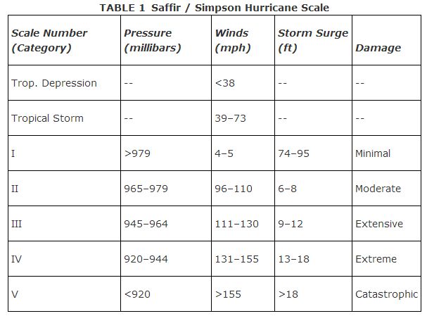
A cluster of thunderstorms that stays together for a few days can begin to rotate. This occurs over warm ocean water (over 80°F). Water that is evaporated from the surface condenses in the cloud, releasing a tremendous amount of energy. This feeds the system even more, causing a low‐pressure system to form. As the system grows, the winds at the center of it rise upward. If these winds are allowed to spiral outward at the top of the system, the system will grow and gain strength. A tropical depression is formed. When the maximum sustained winds reach 39 mph, it becomes a tropical storm and is named. If the maximum sustained winds reach 74 mph, it is called a hurricane. Once the storm reaches hurricane status, it is classified by the Safir‐Simpson Scale. This rates the hurricanes based on central surface air pressure, maximum sustained wind speeds, storm surge, and damage (actual or potential). The scale ranges from Category I to Category V. These values can be seen in Table .
The naming of hurricanes started in 1953, using female names. Prior to that time they were named for the area that they impacted the most. In 1979, male names were added, alternating with the female names. Each year the National Weather Service generates a list of names to be used in alphabetical order. The NWS currently has six lists of names which it uses in a six‐year rotation. If a hurricane is particularly devastating, the name is retired.
The global winds act as steering currents for hurricanes. As the hurricane grows, an eye develops in the center. This is an area of calm winds and clear skies. Around the eye is the eye wall, which is a wall of clouds and strong winds. Around the eye and eye wall are spiraling bands of clouds and heavy rain. These feed the system with energy. Besides the sustained winds and torrential rains, hurricanes drag a bubble of water along with them. This storm surge can flood areas. As a hurricane makes landfall, a lot of friction with the ground occurs. This can result in tornado formation.
After the hurricane makes landfall, it loses its energy source by not being over the warm ocean waters. Within a few days it falls apart, usually just drenching areas with rain. The winds don't usually factor in damage at this point.
When warnings and watches are issued for hurricanes, several steps should be followed to ensure safety. Buildings and windows should be boarded up. All loose items should be put away or firmly secured. Water, canned food (with a manual can opener), and first‐aid kits should gathered. Evacuations may be ordered by local authorities. A plan for meeting your family members should be in place for any emergency.